May
May, Mai or Maï is nowadays Kayasu and is considered a relevant archaeological site, discovered by prof. H. Bahar (Selçuk University). It is a second millennium settlement, whose location within the on-going search for Tarhuntassa has been recently underlined by M. A. Jones [1] in his dissertation (2019: 35–36, 41, 197, 207–209, 258). This toponym is "Mai" in Sterrett's map, a name used instead by Ramsay for the river flowing south of Dinorna, that he calls "Mai Chai", while in the former's map it is "Tekke Tchai" (Sterrett 1888 [2]: 148–149, 153). The diffusion of this toponym in a region between lake Suğla and Çumra makes it more likely that "May" is a relic of ancient times and not a Turkish word (ma–mai, water or mawi, "blue", "watery"). Considered that distant places bear Mai-names, such as, from east to west, May Dam (May Baraji), near Çumra, where Kay river alluvial waters are restrained, and the canyon Mavi (Mawi=May?) Boğaz through which Çarsamba Çay flows after leaving lake Suğla, we should wonder whether it is just a matter of waters and swamplands. Another explanation would allow to sum up some interesting data: May river streambed is meandering and Maiandros (KH 93-94; KON 357, § 752) is the Lydian river which is notorious for is tortuous course. A first hypothesis is to derive its name from the Luwian language: *mai-ant-(al)la- where mai(u)- is a Hattian word for a still undetermined textile (Soysal 2004 [3]: 294) and -ant- the individualizing suffix (Dardano 2010 [4]) as in the Luwian word armantallana- (or in the Hittite utniyant- "country, people" from utne- "land"). The Luwian suffix -la- is a fairly common adjectival suffix (Melchert 2003 [5]: 195) and would be added to hypostatize the winding feature of the river. The Cappadocian toponym Maiandara (TIB2 228, s.v. Malandara) may preserve the idea of an alluvial river fan, where such meanders can be observed. Hulana (Porsuk Çay) is another Hittite river that may owe its name to the winding course (HED 3:361). The Hittite hulana- and the Hattian mai(u)- belong to the same semantic field of textiles and probably both of them gave a contribution to that of hydronomy too. Searching for toponyms that may keep a memory of Mai as ancient region of Isauria-Lycaonia, a good starting point is provided by Meloē (< *Maiel + uwa) (KON 378, § 798-1; TIB5 346), whose precise location is unknown, but supposedly to be found at the eastern border of Isauria. On the western side, an even more concrete trace of Mai in the recorded toponyms would come from the ethnonym Gorgoromeis (KON 142, § 214; TIB4 119, s.v. Akkilise; Hall 1971 [6]; DGE 835), which can be analysed as Gorgyra + *meis, where γόργυρα is an "underground drain or sewer" (LSJ), but more generally a work of canalization (DGE 836; Skoda 1982 [7]: 78). As Gorgoromeis should be located east of Suğla Gölü (TIB4 237, s.v. Trōgits Limnē), a lake well-known for its being a polje ("temporary lake"), the first part of its name may hint at the gorgyra ("underground channel") located in the southern end of the lake, at Arvana (TIB4 134), a toponym that can be viewed as a survival of the Cuneiform Luwian harwann(i)- ("little path"), to be compared with Hieroglyphic Luwian harw(i)- "road" and with the Hittite logogram dKASKAL.KUR, which has been interpreted as "underground watercourse" (Gordon 1967 [8]; Hansen 1997a [9]; Hansen 1997b [10]; Börker-Klähn 1998 [11]; Hansen 1998 [12]). Gorgorome may go back to the Hittite cult of karstic rivers and be the equivalent of "dKASKAL.KUR of Mai". As in Meloē, in Gorgorome too, the component -me- would represent the reduction of the original diphthong -ai-.
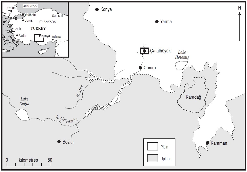
May river basin (from Ayala & Wainwright , et. al. 2017 [13]).
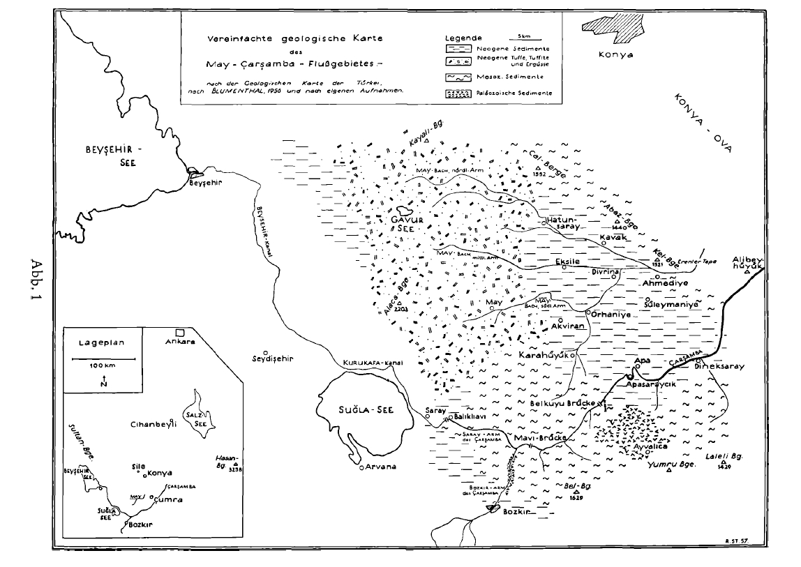
May river basin (from Stellrecht 1957 [14]).
Originally Published: April 4, 2021
Last Updated: May 20, 2021
- Jones, M.A., Searching for Tarhuntassa: using GIS spatial analysis and diverse data-sets to investigate a question of historical geography in Hittite Southern Anatolia. 2019, University of Birmingham.
- Sterrett, J.R.S., The Wolfe Expedition to Asia Minor. 1888, Boston: Damrell and Upham.
- Soysal, O., Hattischer Wortschatz in hethitischer Textüberlieferung. 2004, Leiden: Brill.
- Dardano, P., Zur anatolischen Morphosyntax: Das Suffix-(a) nt-und seine Bildungen. Süel A.(ed.), 2010. 7: p. 25-31.
- Melchert, H.C., Language, in The Luwians, H.C. Melchert, Editor. 2003, Brill: Leiden. p. 170-210.
- Hall, A., The Gorgoromeis. Anatolian Studies, 1971: p. 125-166.
- Skoda, F., Le redoublement expressif. Un universal linguistique, analyse du procédé en grec ancien et en d'autres langues. 1982, Paris: SELAF.
- Gordon, E.I., The Meaning of the Ideogram dKASKAL. KUR=" Underground Water-Course" and Its Significance for Bronze Age Historical Geography. Journal of cuneiform studies, 1967. 21(1): p. 70-88.
- Hansen, O., The Gyges Legend and the dKASKAL.KUR = Underground Water Course. Hermes, 1997. 125: p. 506-507.
- Hansen, O., Dingir. Kaskal. Kur., the Huwasi-Stone, and Carian Gerga. Hermes, 1997. 125(2): p. 231.
- Börker-Klähn, J., dKASKAL.KUR: bauen oder ‘feiern'. Studi e testi I, 1998: p. 9-18.
- Hansen, O., A note on an overlooked Heraclea and the DINGIR. KASKAL. KUR."underground watercourse". Orientalia Suecana, XLVII, 1998: p. 27-28.
- Ayala, G., et al., Palaeoenvironmental reconstruction of the alluvial landscape of Neolithic Çatalhöyük, central southern Turkey: The implications for early agriculture and responses to environmental change. Journal of Archaeological Science, 2017. 87: p. 30-43.
- Stellrecht, R., Ingenieurgeologische Beobachtungen südlich Konya (Mittelanatolien). Berichte der Naturforschenden Gesellschaft zu Freiburg, 1957. 47(1): p. 115-130.